What is Food Mapping?
Food Mapping is a participatory exercise that engages communities in creating art, while mapping food sources, resources, and community assets. This activity invites conversation about the personal health, community, economic, and ecological impacts of our food systems. Learn more about Food Mapping
BEEKMAN CORRIDOR
This map was created through the work of Heather Sayre and the Beekman Community Market, who partnered with residents and local organizations to highlight the rich food landscape of the Beekman Corridor. The project grew out of Food Mapping workshops and community engagement efforts designed to showcase neighborhood food resources, from corner stores and community gardens to free meal sites and local restaurants.
The Beekman Corridor Food Map was made possible with support from the City of Cincinnati Office of Environment & Sustainability and Working in Neighborhoods, along with many community partners who contributed their time and knowledge. Thank you to all who helped bring this resource to life.

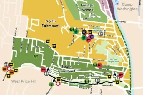
Camp Washington
This map highlights grocery and convenience stores, restaurants and fast food establishments, community and school gardens, meat processing and packaging facilities, and food pantries. This map also identifies some edible fruit and nut trees such as mulberries, peaches, apples, and black walnuts, as well as community assets—The Camp Washington Urban Farm, the Salt Dome, community centers, and cultural and artistic centers (The Swing House, Wave Pool, and the American Sign Museum).
The creation of this map and the Camp Washington Art and Mobile Produce (CAMP) cart was made possible by funding from the City of Cincinnati Managers Office as part of the Engage Cincy Grants.

Covington
This map was inspired and created by conversations with Covington’s residents. The Center for Great Neighborhoods hosted a series of Food Mapping Workshops and community dialogue events to assess our needs and assets, and dream of what Covington may become.
This map was funded by a Kresge Foundation Fresh-Lo Grant and was made possible by all of the residences who participated in our workshops, conversations, and events. Thank you to our workshop hosts: Covington Coffee, Gutierrez Deli, Linden Grove Cemetery and Arboretum, and Pique.

Northside Fruit Park
This Food Map invites you to explore the neighborhood of Northside in Cincinnati, Ohio. Take a walk on the wild side and raise your food consciousness as you realize the true amount of harvestable food that grows in our public domain.
This maps was funded by primarily by Urban Artifact, with additional financial support from Shake It Records, Central Ohio River Valley Local Food Guide, CAIN, Green Umbrella, Northside Village Green, Groundwork Cincinnati, Cincinnati Permaculture Institute, and Cincinnati State Community and Technical College.

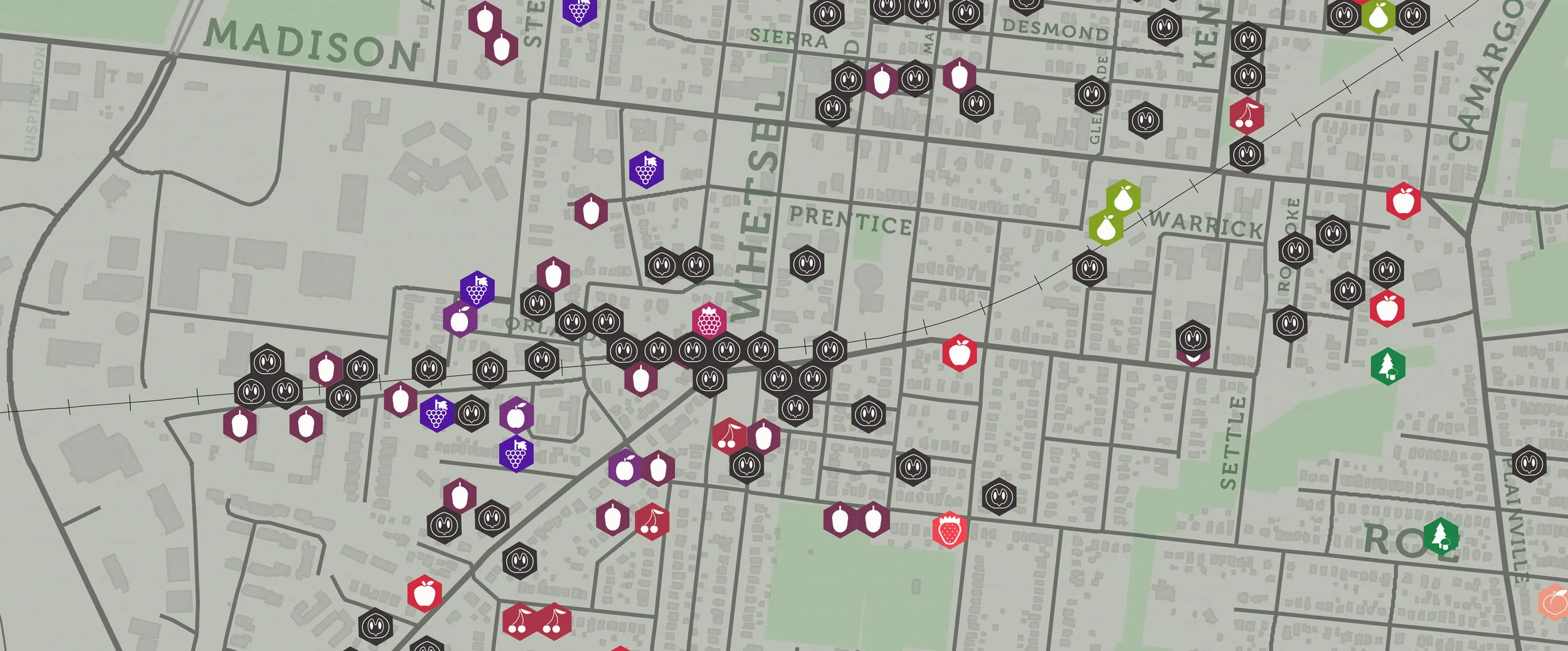
Madisonville
This Madisonville Food Asset Map has three layers of information: 1. Brick and mortar stores (i.e. restaurants) and support centers (child and health care, fitness etc.); 2. Sidestreams 500 Gardens Locations, and 3: Wild Edibles (fruit and nut trees).
This map is a collaboration between Indian Hill High School, the Madisonville Community, Slow Food Cincinnati, and Cincinnati State’s Landscape Horticulture Technologies Division. Special Thanks to our community partners: Madisonville Education and Assistance Center (MEAC), SideStreams, Madisonville Community Council, and Madisonville Community Urban Redevelopment Corporation (MCURC).

Mt Auburn
The Mt. Auburn Gardens Initiative & Collaboration (MAGIC) is a neighborhood based effort between many groups and individuals in Mt.Auburn. This initiative is focused on engaging residents in healthy behaviors though gardening, recreation, and neighborhood beautification activities. MAGIC is working with schools and community groups to activate green space, revive community gardens, and create public food forest pocket parks.

Sayler Park
The Sayler Park Food Mapping Project began in February of 2020. Residents were excited about the possibilities and eagerly participated in the vision process. Two infographics were created focused on food access, fruit and nut tree locations, farms, fast food, gathering places, gardens, golf courses, green space, grocery stores, little libraries, parks, restaurants, recreation centers and trails, neighborhood organizations and groups, schools, and breweries. These maps show Sayler Park’s foodscape. The team also worked to identify future food access and beautification projects.

Walnut Hills
This map is a collaboration between The Walnut Hills Redevelopment Foundation; Cincinnati State’s Landscape Horticulture Technologies Division, and Zone 06.
Walnut Hills Redevelopment Foundation is a non-profit community development corporation working to enhance the quality of life in Walnut Hills. Our Vision is a Walnut Hills that is vibrant, safe, healthy, and inclusive for all. We believe a quality place should be accessible to everyone. To Learn More about Walnut Hills, contact: Gary Dangel: gary@walnuthillsrf.org